ESdat's Analysis functionality is available to users of their own databases. Users can filter, summarise, and export their data to GIS, Surfer, or other supported applications.
There are some limitations, however, outputs which depend on the standard database structure are not available, this includes: comparison with environmental standards, formatted chemistry output tables and the QA Report, and laboratory data cannot be imported in the same manner. In addition, you are responsible for generating the queries you will need to combine or manipulate the data.
The analysis tools available through ESdat are largely independent of data structure. Thus, if you have a table or query it can be analysed through ESdat.
The dialogues shown in the setup process can be accessed at any time under the Setup menu. The procedures for using your own database are given below.
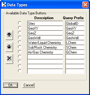
Data in ESdat is grouped under a series of customisable Datatype buttons. These require that a consistent (customisable) prefix is used for queries related to the same datatype, ( eg WL for queries related to water levels). Tables do not appear under the data-type buttons (except for the “All Tables” button)
When you are setting up your database all the database queries will appear beneath the first Data-Type button. You should group your queries by using a prefix and assign that prefix with a description to a Data-Type button. To assign a prefix and descrition select Setup - Date Types - Edit Data Type buttons.

If you choose not to use data-type buttons all your queries and tables are still available under the "All Queries" (Access Only) and "Data Tables" data type buttons.
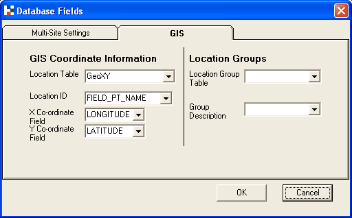
To enable the mapping of data points within ESdat and in other packages you need to specify the name of the coordinate fields and the name of the location identifier field. This is specified in the menu Setup - Database Fields.

ESdat will only be able to produce maps for queries that have an x co-ordinate field and a y-coordinate field (or a open GIS WKB field for polygons etc.. in the SQL Server versions). If your Location Code or co-ordinate field names vary in different tables or queries these will have to be standardised before they can be mapped.